


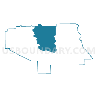
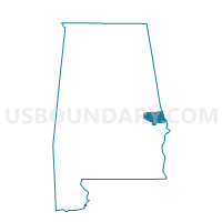
Opelika B Voting District, Lee County, Alabama
About
Outline

Summary
| Unique Area Identifier | 522273 |
| Name | Opelika B Voting District |
| County | Lee County |
| State | Alabama |
| Area (square miles) | 102.21 |
| Land Area (square miles) | 101.09 |
| Water Area (square miles) | 1.12 |
| % of Land Area | 98.90 |
| % of Water Area | 1.10 |
| Latitude of the Internal Point | 32.65286170 |
| Longtitude of the Internal Point | -85.37243420 |
Maps

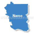
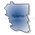
Graphs
Select a template below for downloading or customizing gragh for Opelika B Voting District, Lee County, Alabama


Neighbors
Neighoring Voting District (by Name) Neighboring Voting District on the Map
- Auburn, Lee County, AL
- Beuaregard School, Lee County, AL
- Cusseta, Chambers County, AL
- Farmville, Lee County, AL
- Lee County Snacks Voting District, Lee County, AL
- Old Salem School, Lee County, AL
- Pine Grove United Meth Church Voting District, Lee County, AL
- Sturkie Voting District, Chambers County, AL
Top 10 Neighboring County Subdivision (by Population) Neighboring County Subdivision on the Map
- Auburn-Opelika CCD, Lee County, AL (80,779)
- Valley CCD, Chambers County, AL (13,966)
- Beauregard-Marvyn CCD, Lee County, AL (10,469)
- Loachapoka-Roxana CCD, Lee County, AL (7,236)
- Beulah CCD, Lee County, AL (6,705)
- Waverly CCD, Chambers County, AL (1,242)
Top 10 Neighboring Place (by Population) Neighboring Place on the Map
Top 10 Neighboring Unified School District (by Population) Neighboring Unified School District on the Map
- Lee County School District, AL (56,237)
- Auburn City School District, AL (53,380)
- Chambers County School District, AL (27,747)
- Opelika City School District, AL (26,477)
Top 10 Neighboring State Legislative District Lower Chamber (by Population) Neighboring State Legislative District Lower Chamber on the Map
- State House District 79, AL (52,950)
- State House District 38, AL (44,337)
- State House District 81, AL (43,803)
- State House District 83, AL (41,039)
Top 10 Neighboring State Legislative District Upper Chamber (by Population) Neighboring State Legislative District Upper Chamber on the Map
- State Senate District 27, AL (139,166)
- State Senate District 13, AL (132,777)
- State Senate District 28, AL (131,368)
Top 10 Neighboring 111th Congressional District (by Population) Neighboring 111th Congressional District on the Map
Top 10 Neighboring Census Tract (by Population) Neighboring Census Tract on the Map
- Census Tract 411, Lee County, AL (9,042)
- Census Tract 417, Lee County, AL (8,528)
- Census Tract 405, Lee County, AL (7,652)
- Census Tract 410, Lee County, AL (7,236)
- Census Tract 421.02, Lee County, AL (6,826)
- Census Tract 418, Lee County, AL (6,705)
- Census Tract 9540, Chambers County, AL (6,669)
- Census Tract 402, Lee County, AL (5,133)
- Census Tract 9543, Chambers County, AL (4,708)
- Census Tract 412, Lee County, AL (4,400)
Top 10 Neighboring 5-Digit ZIP Code Tabulation Area (by Population) Neighboring 5-Digit ZIP Code Tabulation Area on the Map
- 36830, AL (33,201)
- 36801, AL (22,214)
- 36804, AL (16,861)
- 36874, AL (7,901)
- 36862, AL (6,623)
- 36852, AL (2,129)
- 36879, AL (2,114)